By Rafe Roughton.
Published 7th February 2024. Last Modified 10th February 2024.
I have complied all, currently available, rights of way maps for England and Wales using data from Barry Cornelius (rowmaps.com). With the merged datasets, I have complied a set of essential statistics for Rights of Way in the UK. Any region which is not support on this site will, naturally, not be included in the statistics below. Though the regions we do not currently cover tend to be small in nature, please bear this in mind. Nonetheless, the statistics below paint a useful broad picture of the state of rights of way in the UK. We have included a download link to the appropriate combined dataset below. Please feel free to share this page, any data and any images or charts – everything on this page is released under CC0 (Public Domain).
This data is accurate to 7th February 2024 – we will update these stats once we obtain data on the missing councils.
Net Rights of Way
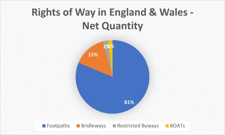
- Total Routes: 525,381
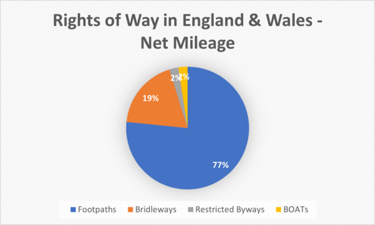
- Total Length: 137,228.80 Miles
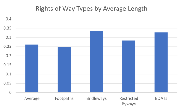
- Average Length: 0.2612 Miles
Footpaths
- Total Number: 427,301 (81.33%)
- Total Length: 105,125.807 Miles (76.61%)
- Average Length: 0.2460 Miles
Bridleways
- Total Number: 76,495 (14.56%)
- Total Length: 25,548.148 Miles (18.62%)
- Average Length: 0.3340 Miles
Restricted Byways
- Total Number: 11,525 (2.19%)
- Total Length: 3,264.892 Miles (2.38%)
- Average Length: 0.2833 Miles
Byways Open to All Traffic (BOATs)
- Total Number: 10,060 (1.91%)
- Total Length: 3,289.951 Miles (2.40%)
- Average Length: 0.3270 Miles
Chicago Manual of Style Citation:
- Roughton, Rafe. “Rights of Way Statistics.” Rights of Way UK. Last Modified 10th February 2024. https://rightsofway.uk/rights-of-way-statistics/